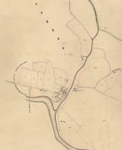
This is a section of the Bellingham Tithe Map of 1845 showing Bellingham and the surrounding area. The original tithe map also has a list which is known as an award. Individual properties are numbered on the map and details of ownership can be found on the award.
The payment of tithes started in England in the 8th century [700-799AD]. At first tithes were payable in kind - 10% of farm produce was payable to the local parish. In 1836 an Act of Parliament changed the payment to a rent-charge payable in cash. In order to set up this charge, a large-scale map and award were created for most English townships. These documents are known as the tithe award and map. Three copies were made. One copy was for the Bishop [Diocese], the second copy was kept by the local church [Parish], and the third copy was made for the Tithe Office. The Northumberland Archives Service now holds the Diocesan copy and many of the parish copies. The Tithe Office copy is held at The Public Record Office.