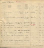
This section of a page from the 1910 Land Valuation book identified particular properties at Powburn. For example, entry number 19 relates to the Plough Inn. The occupier is identified as John Wm. [William] Robson and the owners as the "Heirs of J. R. Carr Ellison". The gross annual value is £39 [roughly £1,600 at today's values] and the rateable value is £33 - 5 shillings [roughly £1,300 at today's value] Powburn formed part of the parish of Glanton. The Carr-Ellisons were substantial landowners in the Glanton area and it may be possible to find further reference to the Plough Inn amongst their estate papers. The 1910 Finance Act introduced a new form of taxation on property in England and Wales. The value of many properties had increased because of the introduction of new public amenities such as road or drainage systems. In such cases the property owner was to be taxed on any profit made as the result of selling that property. The tax was short-lived - it was withdrawn in 1920. By this time the Inland Revenue had assessed all properties in England and Wales. Some of the records relating to this valuation are held at the Public Record Office However, valuation books and maps which were prepared as part of the valuation process are held in County Record Offices. These comprise large scale Ordnance Survey maps and accompanying volumes that record basic details re. each property. The maps and volumes relating to many properties in Northumberland are held by Northumberland Archives Service.