| Communities > Scremerston | About Contact |

Scremerston |
Seahouses |
Scremerston township lies on the North Sea coast in the most northerly area of Northumberland, approximately 3 miles south of Berwick-upon-Tweed. In Parson and White's Directory of 1827 it is described as a township containing a colliery, three fertile farms and a number of scattered houses. It sits within Scremerston ecclesiastical parish, which covers a wide area.
The lands historically were held by the Radcliffe family, Earls of Derwentwater, but when James the last earl was tainted in 1716 the lands were granted to the Commissioners of Greenwich Hospital. At the end of the nineteenth century the sole landowners are given as the Lords of the Admiralty.
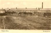
Geological variations in this area allowed many seams to develop, some two feet thick, and were among the earliest coal formations in Britain. There were extensive collieries and manufactories of lime, bricks and tiles around Scremerston, and this, as well as agriculture, were the mainstays for employment for people in the area. The soil is of a clay nature, perfect for the making of bricks and tiles. Crops such as wheat, beans, barley, oats and turnip were grown. The parish is largely agricultural, but the influence of mining is responsible for the growth of the township, though today all of those mines have been closed. The Anglican church of St. Peter's stands here, consecrated in 1842 and built in the early English style. There was also a Primitive Methodist chapel built in 1886 at a cost of nearly £400. The population for 1851 is given as 1,152 people though by 1891 it had fallen to 890.