| Communities > Corbridge > Plans | About Contact |

Corbridge - Plans
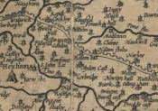
Speed's map of Northumberland (1610)
 This is a section of John Speed's Map of Northumberland published in 1610 showing the area around Corbridge. As with other early maps, John Speed used illustrations to represent features. For example, a village is illustrated by a drawing of a church.
The map is one of a series of fifty-four Maps of England & Wales published by John Speed between 1608 and 1610. The scale of the map is approximately one inch to four miles.
This is a section of John Speed's Map of Northumberland published in 1610 showing the area around Corbridge. As with other early maps, John Speed used illustrations to represent features. For example, a village is illustrated by a drawing of a church.
The map is one of a series of fifty-four Maps of England & Wales published by John Speed between 1608 and 1610. The scale of the map is approximately one inch to four miles.