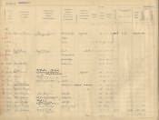
This page from the 1910 Land Valuation book identifies particular properties in Hepscott. Entry 30 relates to a house, shop, byre and land, which are situated on the north side of the village. The occupier and owner is identified as blacksmith Francis Cowans. The gross annual value of the property is £9.5s [approximately £388.50 at today's value] while the rateable value is £8.10 [approximately £357 at today's value].The 1910 Finance Act introduced a new form of taxation on property in England and Wales. The value of many properties had increased because of the introduction of new public amenities such as road or drainage systems. In such cases the property owner was to be taxed on any profit made as the result of selling that property. The tax was short-lived - it was withdrawn in 1920. By this time the Inland Revenue had assessed all properties in England and Wales. Some of the records relating to this valuation are held at the Public Record Office However, valuation books and maps which were prepared as part of the valuation process are held in County Record Offices. These comprise large scale Ordnance Survey maps and accompanying volumes that record basic details re. each property. The maps and volumes relating to many properties in Northumberland are held by Northumberland Archives Service.